Showing posts with label hiking. Show all posts

Tuesday, July 2, 2013

A Girlie Girl on the Westcoast Trail

I do not intend this post to be a guide on the trail, after all, there are many detailed accounts from experts. This post is about my perspective as a non-athlete, 5' 1 city girl (well, mom, actually). 

I'd be the first to acknowledge that I am not athletic nor tough. It took me over a year to convince myself to actually decide that, yes, I will do it -- this infamous trail that have claimed some lives. Despite all the facts stating that, no, it's not for you, Liza, I did as I do when I'm afraid, just closed my eyes and jumped anyways (not literally, obviously). I did read up a lot on it, so that I knew what to expect (it would be irresponsible if I didn't.) It was more than just a physical achievement, the West coast Trail was a "mind thing. Determination played a huge part in finishing it.

It wasn't important to us to do it in record time (on our third day, five guys with only camel packs with the goal of doing it in ONE DAY passed us! Apparently, they swam across the river too.) We took 7 days to do 77 km (included a 2 km hike to Thrasher Cove campsite, which was known to be one of the more difficult section, it's not on the path, many trekkers we have met chose to bypass this beautiful place).


Monday, April 1, 2013

Oyster Dome, Deception Pass, Anacortes

View at dusk from Lighthouse Point trail in Deception Pass [Photo by: Where is Liza©]

We all know by now how beautiful the Pacific Northwest is. Knowing this, I am still in awe every time I am staring at its splendour.


The San Juan Island area in Washington is the equivalent of our Vancouver Island (without having to take the ferry and shelling out your life savings). It consist of various islands, breathtaking cliff side views, arbutus trees sprinkled everywhere, hiking trails aplenty, and that small town feel that makes you feel like you are on vacation.

Our first stop of on this road trip is Oyster Dome off Chuckanut Drive, south of Bellingham. The original plan was to do either the 3.8 mile or 6.5 mile hike. This didn't happen because we did not get our Discovery Pass that is necessary to park in any of the Washington area parks. We are however able to drive all the way up to the lookout point which is of course spectacular. It would have been very cool to see hang gliders because it is known for it, but oh well. 

Aside from knowing that we will be camping, we actually haven't made any concrete plans on where we will be staying. So we keep on driving south and figure that we will make a decision  when we see something interesting.


[Photo by: Where is Liza©]
[Photo by: Where is Liza©]
"Interesting" has brought us to Deception Pass campground. It's perfect -- no Discovery Pass required to camp for the night. With the sound of the ocean in the background, we set camp at around 7  pm. 15 minutes before 8 pm, we are putting on our headlamps for a hike to Lighthouse point. At this time, there is still some light, but it is getting dark. We follow a trail that goes to the beach and then up to the forest, and then to more of that breathtaking stuff I've been talking about (see first photo above). It is rugged, wild and crazy beautiful. (After a few minutes, it did get quite dark; I'm sure glad that I brought those headlamps). The hike only took about an hour, with plenty of stops for photos and ooohings and aaahhhings.  


[Photo by: Where is Liza©]
The next day, we drive to Anacortes, which is in Fidalgo Island. It's a very quaint town  with buildings that feel like it's been there for a very long time. I can just imagine that this place must be quite populated in the summer/tourist months. 


Washington Park - Anacortes [Photo by: Where is Liza©]
For the future, we drive to see the other state park in the area -- Washington Park. And yup, it's beautiful. We prefer the Deception Point campsite better, but the scenery is something else.  

We hope to come back to do some hiking in this area.


Washington Park - Anacortes [Photo by: Where is Liza©]


Anacortes [Photo by: Where is Liza©]

Anacortes   [Photo by: Where is Liza©]


Saturday, March 30, 2013

Killarney Lake Hike - Bowen Island

This was not so much of a hike but more of a scenic stroll in an island. I had been so lazy all winter with only yoga, the occasional paddle and snowshoeing, so I know that I needed to ease into my activities.   


Because of the ferry ride, Bowen Island gives you the feeling of going "away." Killarney Lake was a mere 9 km of easy and scenic ramble. This was the perfect place to break in my new hiking boots (hard to believe that I was so excited with this purchase at MEC, when not too long ago, I only had eyes for 6" heels). The hike around took us 3 hours, but that's only because we took a very leisurely break at the picnic area. 

So now, enough  with the leisurely jaunt around the park, I need a challenge. I need to start training for the West Coast Trail for this summer which had been known as "being one of the most grueling treks in North America." 

Let the games begin!?


Sunday, August 21, 2011

Baden Powell: Part 2: Grouse Mountain to Horseshoe Bay


Eagle Bluffs

Wow, despite being more difficult, I have enjoyed this hike (according to the West Van website, ... "The hiking time from Cleveland Dam to Horseshoe Bay is more than 12 hours commencing with a fairly steep climb for the first 45 minutes out of the Capilano Valley and through the upper British Properties") a lot better than the first part of Baden Powell (the absence of rain and thunderstorm most likely helped plus the much more streamlined backpack). We started at 8:15 am just a little off Grouse Mountain at Cleveland Dam and were having a very cold hefeweizen in Deep Cove by the next day at around 2pm.


One of the cabins along Cypress
Warming lodge in Cypress
There's still snow on some areas

Cleveland Dam to Cypress Mountain (11 km) was a reasonable hike. We rewarded ourselves with an ice tea at the chalet, rested our feet for a bit and just enjoyed the sun. We started again at 3:30pm and began the seemingly unending ascent, knowing what we know now, though, it was nothing compared to what was coming up towards the end. We were quite rested and were feeling pretty good at this time, we were prepared to hike for several more hours intending to stay overnight at Eagle Bluffs. But there were so many beautiful lakes along the way at the Black Mountain area that we were enticed to stay and ended up setting up camp in one of them at around 5pm. Each lake was more beautiful than the next. If you don't mind the cold water, they are swimmable. We would have gone in if it was earlier in the day with the sun a blazing, but because it was already late, we didn't want to be cold and wet for the evening. We started our camp fire and had our pad thai dinner and just enjoyed the peace and the view of the lake with the occasional swoop of a crane (I think, it's a crane, but I'm not sure).


Owen Lake


The next day, we started our fire at around 7am and were soon having our porridge and coffee. We were packed and ready at 8:15.  We knew that what was ahead will be the hard part -- and it was. But first, Eagle Bluffs -- this place is what BC is all about. It is breathtaking. It is beautiful. This is the place where you would contemplate on how lucky we are to live in such a place.


Now, the fun part, the descent!!!  Rocks, rocks and more rocks -- sometimes boulders, sometimes smaller, but a river of rocks to go down on. The most important thing I have brought on this hike were a pair of suede gloves, they enabled me to hang on to the often sharp rocks, allowing me to pull myself this way and that way. After  this, everything else was not as bad -- there was still another river of smaller rocks, a few logs to cross (think scene from The Lion King when Pumba,Timon and Simba are crossing the log), and many many steep places with roots and yet more rocks to impede you.


I'm not sure why there is this massive explosive
along the way, I sure hope it's not working.
giant 'shroom

I knew I was enjoying my hike when I noticed that after each difficult section, I would sing to myself (and sometimes a little louder) ...


I can see clearly now, the rain is gone,
I can see all obstacles in my way
Gone are the dark clouds that had me blind
It’s gonna be a bright (bright), bright (bright)
Sun-Shiny day.

I think I can make it now, the pain is gone
All of the bad feelings have disappeared
Here is the rainbow I’ve been prayin?for
It’s gonna be a bright (bright), bright (bright)
Sun-Shiny day.

Look all around, there’s nothin?but blue skies
Look straight ahead, nothin?but blue skies

I can see clearly now, the rain is gone,
I can see all obstacles in my way
Gone are the dark clouds that had me blind
It’s gonna be a bright (bright), bright (bright)
Sun-Shiny day.


Deep Cove

Saturday, July 9, 2011

Baden-Powell Trail: Northshore

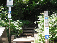
Baden Powell entrance to the hike in Deep Cove

Despite all the news lately about bears in the North Shore, I embarked on my very first overnight hiking expedition. The Baden-Powell trail is not meant to be done as one continuous hike but as a series of smaller ones. It is 42 km/ 25 miles, some trails are easy to moderate, but there are areas that are considered advance. I would have really liked to finish the entire thing, but due to time constraints, it is just not possible. We parked our car in Deep Cove, and loaded with our overnight gear of tent, sleeping bags, food and change of clothes, we begin. It's a pretty easy/moderate beginning. It must have started to rain about 3-4 hours into the hike, initially we put on our plastic ponchos, but it got so hot because you are sweating so much, so we were wet from the rain, and we were wet from the inside of our ponchos from sweat. I figured I couldn't be wetter anyways, so I just took off the plastic poncho and just wrapped my pack with it (it would be nice to have dry tent and sleeping bags). Our first stop was Lynn Canyon, it's only 12 km from Deep Cove, but it takes about 5 hours because of the difficulty of the terrain.We continued our hike for 3 more hours after that. The one thing I really disliked about this particular trail are the neighbourhood areas, I felt like a derelict with my wet hair and my huge backpack walking through the neighbourhood of Lynn Valley. We soon found our trail in the bushes again but I just didn't have much energy to go on, we set up camp. It was pretty early in the evening, but I was just exhausted plus there are mosquitoes a plenty -- so we went to bed early after eating our yummy jerky and boiled eggs. It was really nice of mother nature to entertain us with a show of thunder and lightning.

The next day, we woke up thankfully sans rain. We were grateful to have change of dry clothes. Our destination was Grouse Mountain. Wow, this day started out hard right away. Continuously and endlessly uphill. Ugghhh!! Some of the areas were just rocks and ravines, with logs to cross over. Up down, up down with our heavy backpacks. The scariest part for me is being thrown off balance with my pack, I'm just not used to it yet. I just didn't want to end up toppling back like a turtle on the steep areas. It was just before noon when we got to Grouse Mountain. Thank God for the Starbucks there.

We then walked to Cleveland Damn after and decided to end our hike there. This is where we will start our next hike in order to finish the entire thing. The trail here will take us to Cypress, through the Black Mountain area, then to Horseshoe bay. This part of the hike is supposed to be the hardest and steepest! Yikes, can't wait.

We then take the bus back to Deep Cove to get our car. We reward ourselves with fish and chips and a very cold one each.

Monday, July 4, 2011

Lolo Peak: Montana

Not an attractive look - it was rainy and snowy.
Lolo Peak: We managed to have our wine and cheese somewhere close-ish to the peak, however, I am ashamed to say, that we did not make it to the top. I went in early June but it was still snowy, and I just was not equipped with my fair weather hiking shoes (ventilated and not water proof). I think the other people ahead of us brought skis. But nonetheless, it was a beautiful ascent.

Spring Hopping: Montana & Idaho

Magnificent rocks in front of the campsite
If you plan on doing this activity, I warn you now, that you cannot be the timid type. There may or may not be nudity.

The first one we went to was in Montana, called Lolo Hot Springs, it's adjacent to a campsite. It hasn't been upgraded in a few years, so it's quite old school. They have an outdoor and indoor pool, a restaurant, a bar and snowmobiling in winter.

Second one is in Idaho (a short drive from Lolo) called the Jerry Johnson Hot Spring. It's free but there is a short and easy hike to get there. There are two springs, they're a bit muddy when somebody gets up or gets in the pools, but otherwise, its a nice soak. 

The third one is my favourite, it's also in Idaho, Weir Hot Spring. This place is one of those places that you have to be in the know to find, it is unmarked outside. The trek is NOT easy - we even had to put our feet in very cold water to cross in a couple of the areas, but... so worth it. It was lucky that when we finally got to the spring, there was nobody else there, it added to the feeling of finding your personal secret paradise.


Monday, April 18, 2011

Othello Tunnels & Old Settler Pub


If you are going to be on the Hope or Coquihalla area, check this place out. 

"... These tunnels were designed by Andrew McCulloch to save going around the Coquihalla Canyon. The railbed crosses the Coquihalla River several times and the views are well worth the trip. The trestles have all been converted to walkways now, and it is a provincial park. It is located about 5 km outside of Hope."
(http://www.thekvr.com/othello.php)

It is one of those beautiful BC places to hike -- water rushing, monolithic boulders -- BC at its best. The main trail is an easy hike. There are however, more medium trails off the main one. We have decided to turn around, though, upon seeing bear poop as we aren't equipped for a possible confrontation. 

To complete our rustic day, we thought we would eat locally. Unfortunately, it was pretty dead everywhere in Hope at 7pm Saturday night. So off, we go again on our small road trip. We decide to go to Harrison Hot Springs. Still sticking to "rustic" we go to the Old Settler Pub. It is a nice change to go to a place where it's not a "Donelly or Mark James" type. We both have a "stick to you ribs" food - meat, potatoes and beer -- very authentic.

If you have a day, this is one good excursion away from the city.